
Piri Reis map: the 1513 chart that may carry traces of Columbus
In 1929, researchers at Istanbul's Topkapı Palace Museum noticed an old map drawn on gazelle skin, made in Gallipoli in 1513 by Piri Reis.
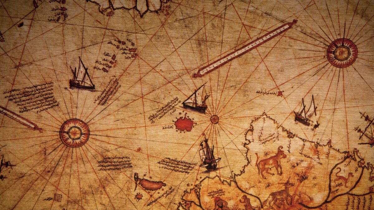
In 1929, researchers at the Topkapı Palace Museum in Istanbul turned their attention to an old map drawn on gazelle skin. An Arabic note on it said it was made by Piri Reis in the city of Gallipoli in 919 AH, that is 1513. The map showed the Atlantic Ocean, the coasts of Spain and West Africa, the coast of South America and the islands of the Caribbean Sea. A Turkish inscription said parts of it were taken from a map by Christopher Columbus.
Who was Piri Reis?
Scholar Svat Soucek writes in the University of Chicago Press’s “History of Cartography” that his full name was Muhiddin Piri Reis and that he lived from about 1470 to 1554. In Turkish, “reis” means a ship’s captain. His father was named Haji Mehmed. According to an unverified account, he was born in Gallipoli, which was then the largest base of the Ottoman navy.
According to Soucek, after 1481 Piri Reis began sailing with his uncle Kemal Reis, who later became an admiral in the Ottoman navy. From 1487 to at least 1510, during voyages along the coasts of North Africa, Piri Reis kept gathering the notes that later formed the basis of his famous book. After his uncle died in 1511, he returned to Gallipoli. There he began work on both the world map and his book.
How was the map made?
On the left side of the map, near the centre, is an Arabic inscription of three lines. According to Soucek’s translation, it says that the map was drawn by “Piri, son of Haji Mehmed, nephew of Kemal Reis, the humble one” in the city of Gallipoli in Muharram 919 AH, that is March-April 1513.
The map also carries many inscriptions in Turkish. In one of them, Piri Reis himself explains how he made it: “No one has had such a map before. This humble one drew it with his own hand.” According to Soucek’s translation, he collected about twenty sources for it. These were eight world maps said to date from the time of Alexander the Great, which the Arabs called “Jafariyas”; an Arab map of India; four recent Portuguese maps showing regions as far as India and China; and a map of the “western lands” drawn by Columbus. Piri Reis writes that all of these were brought to a single scale to prepare the map. Soucek believes the maps from Alexander’s time probably mean the maps of the ancient Greek geographer Ptolemy, and that the word “Jafariya” is perhaps a corrupted form of “Jughrafiya”, the Arabic title of Ptolemy’s book.
A lost map of Columbus?
According to Soucek, during his third voyage in 1498 Columbus drew a map of the New World and sent it to Spain. That map is now lost. The longest inscription on the Piri Reis map says that Kemal Reis had a Spaniard with him who claimed to have gone on three voyages with Columbus. It also says: “The coasts and islands of the New World on this map have been taken from the map of Colombo.”
This is the main reason for the map’s fame. In 1933, the German orientalist Paul Kahle wrote a paper on it titled “A Lost Map of Columbus”. Soucek says the Italian scholar Roberto Almagià compared the place names on the map with those used by Columbus. He suggested that a more accurate title would have been “The Columbus imprint on the Turkish map of 1513”. In other words, it is not Columbus’s original map but information drawn from it.
The influence is clearly visible in the Caribbean part of the map. According to Soucek, the island of Hispaniola is turned by about ninety degrees. Cuba is shown not as an island but as a tip of land jutting out of a continent, exactly as Columbus believed it to be. In the same corner is a picture from an old European tale, in which the sailors of Saint Brendan mistake a whale’s back for an island and light a fire on it. According to the inscription on the map, the episode was taken from “old world maps”.
How large was the map?
According to Soucek, the surviving part measures about 90 by 63 centimetres and is only the western fragment of a larger world map. The curve of the south-western part follows the natural shape of the gazelle skin’s neck and shoulder. The eastern edge is torn lengthwise, and an inscription about the Gulf of Guinea is cut through the middle.
According to Soucek, in 1517 Piri Reis presented the map in Cairo to the Ottoman sultan Selim I. After that the map remained unknown for centuries. In 1929, Gustav Adolf Deissmann was working at the Topkapı Palace Museum at the invitation of its director, Halil Ethem Eldem. He showed the surviving western part to Paul Kahle. The map is still preserved in the library of the Topkapı Palace Museum. Soucek says another map by Piri Reis has also been found, dated 1528. It shows the Azores, Greenland, Newfoundland, Florida and the coasts of the Caribbean.
The Kitab-ı Bahriye
The greatest work of Piri Reis is the “Kitab-ı Bahriye”, or “Book of the Sea”, a collection of sailing directions for the Mediterranean. Each chapter deals with one coast or island and comes with a map of it. According to Soucek, it was produced in two versions. The first was completed in 1521 and had 130 chapters and maps. The second, in 1526, had 210 maps.
After Sultan Suleiman came to the throne in 1520, Piri Reis wrote the book to present it to him. In 1524 and 1525 he was the pilot of the ship that carried Grand Vizier Ibrahim Pasha to Egypt. On the way he showed his book to the Grand Vizier, who advised him to prepare it again in a finer form. This is how the second, more detailed version came about. In its verse preface, Piri Reis writes about storms and winds, the compass, sea charts and finding the way by the stars. According to Soucek’s translation, he says in one place that this knowledge does not come from maps alone, that it has to be described, and that it cannot be measured with compasses: “That is why I have written in such detail.”
According to Soucek, Piri Reis died in 1554. Both versions of his Kitab-ı Bahriye survive today in several manuscript copies in the hands of different scribes.
Next instalment: Balboa: the first European sight of the Pacific.
Sources
- Svat Soucek, "Islamic Charting in the Mediterranean", in J. B. Harley and David Woodward (eds.), The History of Cartography, vol. 2, book 1: Cartography in the Traditional Islamic and South Asian Societies, University of Chicago Press, 1992, chapter 14 (sections on Piri Reis, the 1513 world map, fig. 14.5–14.7 captions, the 1528 map, and the Kitab-ı Bahriye). https://press.uchicago.edu/books/HOC/HOC_V2_B1/HOC_VOLUME2_Book1_chapter14.pdf
- Paul Kahle, "A Lost Map of Columbus", Geographical Review 23 (1933), pp. 621–38 (cited through Soucek, note 12). https://www.jstor.org/stable/209247
- "Piri Reis map", Wikipedia (pointer only, used to locate the Soucek chapter and Kahle's article). https://en.wikipedia.org/wiki/Piri_Reis_map
 More from Expeditions
More → Portuguese sailor Gil Eanes rounds Cape Bojador in 1434
 Pytheas: from the Mediterranean to Thule, where the sun does not set
 Rabban Bar Sauma: the Beijing monk who travelled to Rome and Paris
 Scylax: Darius's sailor from the Indus to the Red Sea
 Seydi Ali Reis: the Ottoman admiral who came home via Gwadar, Sindh and Central Asia
 Sulayman the Merchant: the ninth-century sea route from Siraf to Canton
 The monsoon secret and the Periplus: when Roman-era ships anchored at the Indus mouth
 Vasco da Gama: the sea route from Europe to India